Nov. 2010- Nov. 2011
1. THE COMPANY
After a modification to its shareholders structure in November 2011, Squatex became an open society ruled by the market authorities. Although being an open society, Squatex's titles are not traded at present.
2. ST. LAWRENCE LOWLANDS
Following public meetings organized in the fall 2010 by the “Bureau d'audiences publiques sur l'environnement” (BAPE) of the 2Ministère du Développement durable, de l'Environnement, de la Faune et des Parcs” (MDDEFP), a report was produced in February 2011. A recommendation to form a Strategic Environmental Evaluation committee (CEES) to study and recommend for the end of 2013 ways to follow for drilling and complete oil and gas wells. In February 2013, the Minister of the MDDEFP enlarged the BAPE mandate to consult also on shale gas exploration and exploitation and experts hired to run the CEES were then moved to the BAPE.
A direct consequence to these studies and committees and because rules were becoming nebulous, exploration work on permits by Squatex and its partners became very limited. Bill 18 was voted in June 2011 to cover problems related to the time involved for the presentation of the commission report. This law relieves permits owners to fulfill their work obligations under the Mining Law until a later date that will be determined by the Minister, no later that June 13, 2014. Validity of the permits are suspended for the period (3 years maximum). At the end of this period, renewal date of permits will be reported to the end of the execution period in which exploration work were to be performed.
As far as the St. Lawrence Lowlands are concerned, Squatex and its decided in the fall of 2011 to abandon the Canbriam Farnham no 1 (A-271). The well area was decontaminated at the MDDEFP satisfaction and a cement plug was injected in the hole. Canbriam Energy Inc from Calgary, the operator, is waiting for a permit to complete the abandonment procedures. Information obtained from the MRN and the MDDEFP confirm that the well was in July 2013 in good standing as far as environmental regulations are concerned.
Because Bill 18 allows a reporting od work obligations until June 2014, partners have accepted to report the agreement dates accordingly. Canbriam is keeping its other options to earn a 60% interest over an additional 24000 Ha within permits 2009RS296 and 298 in drilling up to 6 vertical/horizontal wells in paying in cash up to 13,5 M$ (9,45 M$ to Squatex and 4,05 M$ to Petrolympic).
3. LOWER ST. LAWRENCE/GASPÉ
For the period from November 2010 to November 2011, most of Squatex's exploration work was performed over the Lower St. Lawrence/Gaspé permits.
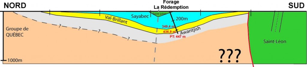
During April and May 2011, two other deeper mining type coreholes were drilled over permit 2009PG556 south of Mont-Joli (Figures 1 and 2). These wells were aimed at a better understanding of Lower Silurian stratigraphy within the Matapedia Syncline in relation with the one present in the collapsed basin located to the west of the Syncline.


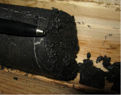
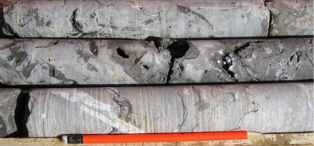
The first hole drilled, the La Rédemption No.1 well. was located in a farmer field near the village of La Rédemption. This coring was aimed at obtaining the complete rock sequence of the Matapedia Syncline and reach the Awantjish shale. The drill was oriented in a SSE direction with an inclination of 70° allowing to remain perpendicular to the formations. Total depth reached was 447 metres. No hydrocarbon trace was observed but interesting highly dolomitize zones were met near the base of the Sayabec limestone (Figure 3). The well was stopped in the Awantjish Formation. No unconformity or explicit thrust fault were seen in the hole (Figure 4).
Respective COT values measured in the Sayabec and the Val-Brillant are 1,90% and 1,42%, and only 0,83% for the Awantjish. RockEval run on the Awantjish suggests a higher maturity (Tmax higher) than the upper formations.
The second coring, the Portage No.1 well, was positioned near the Mitis river on seismic line MRN-2001-02 recorded along the Chemin du portage. This location was aimed at observing the local geology and structure of this area, at calibrating the seismic profile and trying to find a porous zone within the Sayabec limestone.
Two seismic interpretation were to be checked, one with a thrust sheet and the other with a back thrust. The well was drilled vertically to a total depth of 600 metres. It confirmed that the rock sequence is in place and normal. The Silurian Formations were deposited over the Quebec Super Group unconformity (Figure 5). This unconformity was encountered at a depth of 400 metres. Presence of fractures in the well is observed but seems to be relatively minor.
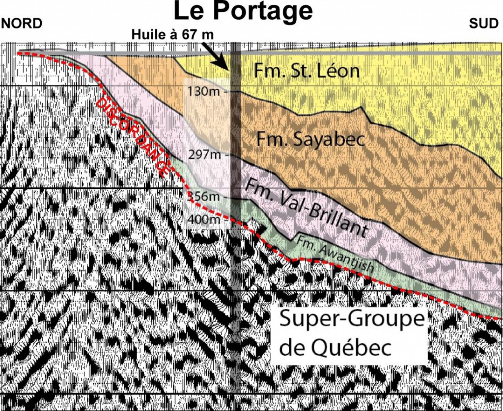
Traces of oil were seen in a fractured zone met at a depth of 67 meters and a small quantity of light oil (50o API) was collected and analysed in the St-Leon Formation (Figures 6 et 7).
Squatex's geologists conducted other field visits in 2011 to verify and validate the new Lower St. Lawrence stratigraphic and structural model. In doing so, outcrops of the Touladi Formation located near the Témiscouata lake were visited because a publication done in the sixties was mentioning hydrocarbons odors on freshly broken rocks. Our field incursion confirmed the characteristic hydrocarbons smell. It also confirmed that this area considered as sterile, located southward from our main interest zone could also show a good potential for oil and gas accumulations.