May 2009- Oct. 2010
During this period, major exploration work was accomplished on Squatex's permits in the St. Lawrence Lowlands as well as in the Lower St. Lawrence/Gaspé.
First, an application to renew Squatex's 2006 permits issued by the government (MRNF) was accepted on September 1, 2009. To do so, a technical permit conversion was requested under the previous Mining Act regulation (which is no longer allowed under the new Mining Act that became effective January 21, 2010). Squatex was therefore able to reduce its statutory obligations because all of its permits start afresh from year one and will remain in effect until 2019 as long as the required work is carried out and the annual rent is paid.
Table 1 shows the new permit numbers corresponding to the old permits in the St. Lawrence Lowlands. The slight differences in area are due to a change in the surface measurement method used by the government. Figure 1 shows the location of permits currently in effect (in red) as well as the old number of the corresponding permit (in black).
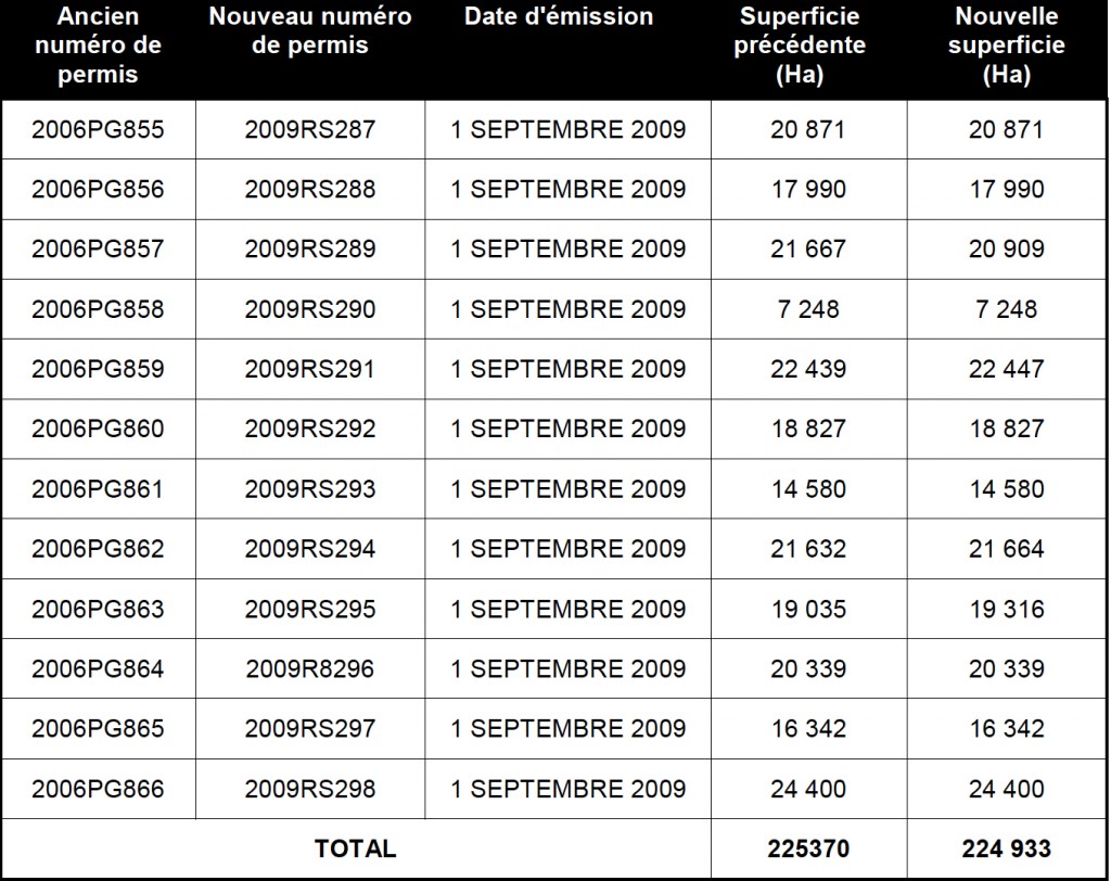
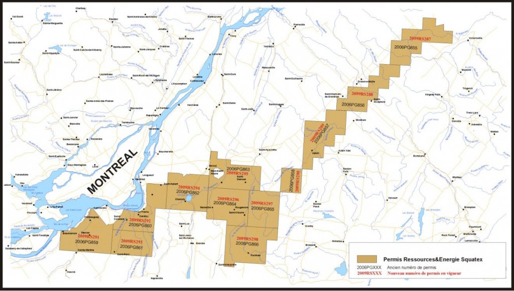
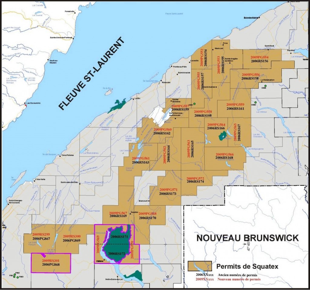
Table 2 is a list of the permits in the Lower St. Lawrence/Gaspé area. The old permit number is shown in order to better understand the link with the previous work done. Figure 2 shows the location of existing permits (in red) as well as their previous number (in black).

1 WORK DONE IN THE LOWER ST. LAWRENCE/GASPÉ AREA
Important geological and geophysical work was done over the Lower St. Lawrence/Gaspé permits area in 2009, namely a high resolution aeromagnetic survey, a gravimetric survey (Bouguer) as well as geological reconnaissance and sampling to determine organic maturity.
1.1 Gravimetric survey
A gravimetric survey was done by Quantec Geosciences Ltd from August to October 2009 over the Squatex's Lower St. Lawrence property region. The purpose of this study was to enhance the existing gravimetric network created by the federal government in the 1950's and 1960's in order to more accurately support the geological reconnaissance of the area and to better define the tectonic framework. The region under review has many folds and fractures and the gravity data outlines contrasting geological assemblages. Figure 3 shows the scope of the survey. A total of 793 stations were recorded over a period of 56 days.

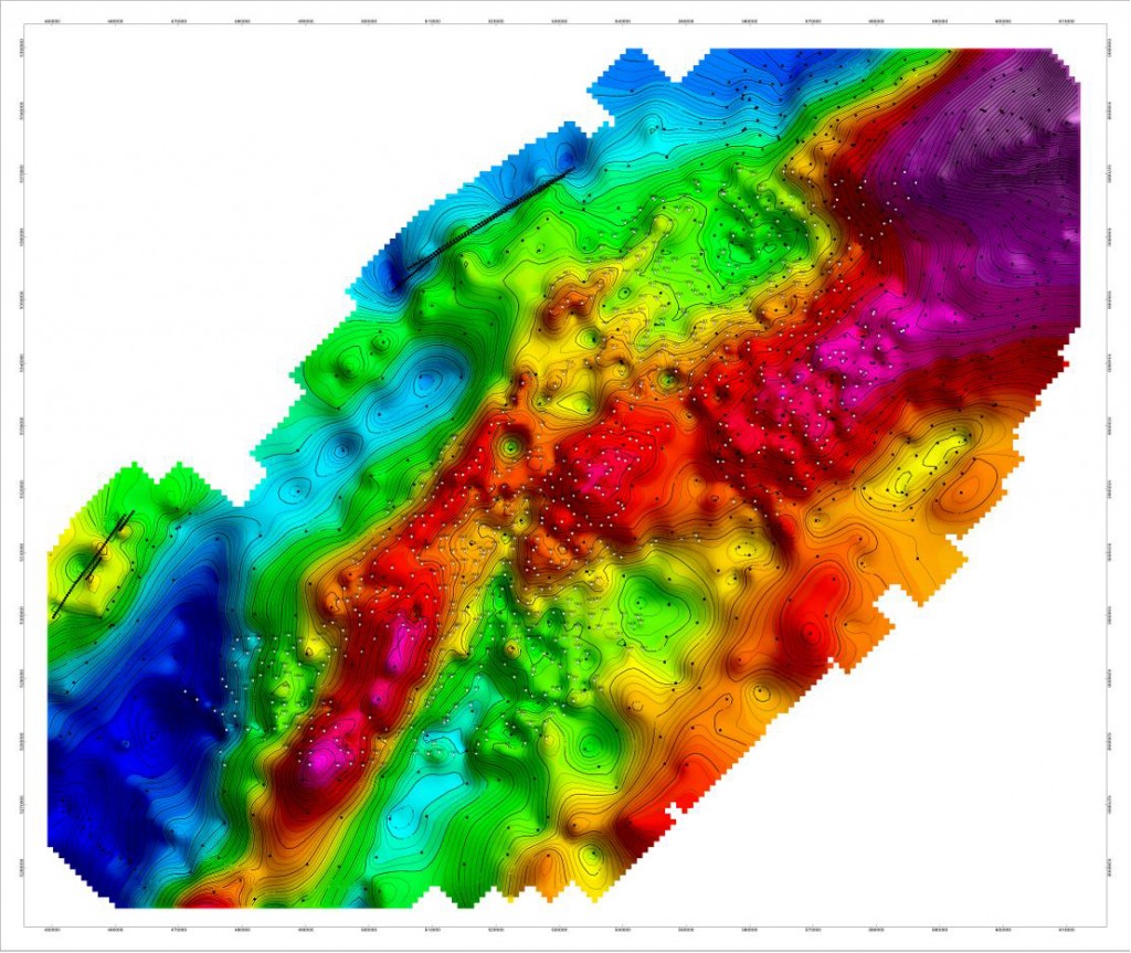
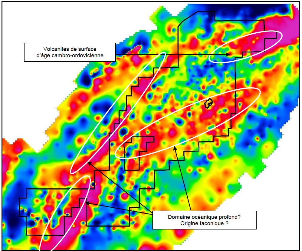
Figure 4 is the Bouguer anomaly map. It shows that the region as a whole is characterized by relatively high gravimetric values in the northern part of the permits where volcanic rock is found at surface and sub-surface. The values are relatively low in the south-west part where the rock assemblies are more of a sedimentary nature.
Figure 5 is the vertical gradient map obtained from the Bouguer anomaly. It shows a representation of geological formations generally located closer to the surface, but with some input from deeper geological formations.
This gravity data will be used jointly with the magnetic data to update the existing geological map and to suggest a tectonic framework that will allow a better understanding of the subsurface architecture. Both data are particularly helpful to identify fault zones that are interpreted on the surface but whose origins could be at great depth. These faults are important because they sometimes delineate distinct tectonic blocks. They could also be indicative of weaknesses in the crust which may have helped the migration upward of hydrothermal fluids responsible for the creation of reservoirs.
1.2 Aeromagnetic survey
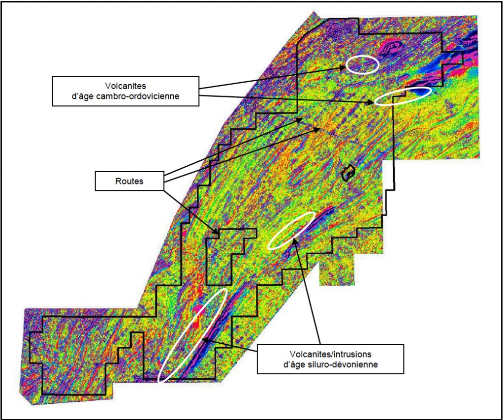
A high resolution aeromagnetic (HRAM) survey was flown by GPR International in August and September 2009 over the entire property held by Squatex in the Lower St. Lawrence area. The objectives of the survey were to measure the magnetic field along flight lines in order to support the lithological reconnaissance of the area as well as the structural cartography (faults, folds, fractures). Rocks in the studied area are highly folded and fractured and show contrasted magnetic signatures. Figure 6 shows the areal extent of the survey. A total of 16,157 linear km were flown over, along flight lines 300 m apart in a NW-SE direction, at an average altitude of 150 m. The data obtained was corrected and processed according to industry standards in order to produce a regular grid of the total magnetic field from which various vertical and horizontal derivatives were calculated.

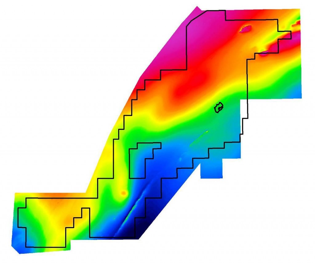
Figure 7 shows the total magnetic field map resulting from the survey. Firstly, it shows a relatively high magnetic field in the northern part where volcanic rocks exist at surface or in sub-surface and a relatively weak magnetic field in the southern part where the rock assemblies are of a more sedimentary origin.
Figure 8 shows the second derivative map that was calculated from the total magnetic field. It represents geological formations generally located closer to the surface. The details provided by this data show the tectonic complexity of the area. The configuration of the observed anomalies allows the recognition and the update of horizon markers indicating a succession of numerous folds towards the north-east, as well as certain discontinuities indicating the probable presence of major faults that were previously unknown.
This magnetic data is being used to update the existing geological map and to suggest a tectonic framework that provides a better understanding of the sub-surface architecture. The geological contacts were adjusted and new faults were added. Field verifications were made in June 2010 in order to validate the interpretation and geological sections will be produced along the various transects in a NW—SE direction. All this work will lead to the proposal of a geological model that will highlight the areas deemed most promising, related to thick sequences of sediments and compartmentalized by faults that are sometimes synsedimentary that may have contributed to the creation of reservoirs. The presence of volcanic units close to these faults is also a factor favouring the development of reservoirs.
1.3 Geological field sampling survey
Following the field work done at the end of 2008, a second geological sampling program of the Lower St. Lawrence outcrops was accomplished during the summer and fall of 2009. The purpose was to refine certain sectors in order to improve our geological knowledge and to continue collecting samples in order to complement the TOC and the (Ro) analysis of the formations to define priority zones having a higher potential for hydrocarbons accumulations.
This study was carried out over the permits between Lake Matapedia to the north-east of Rimouski and Lake Témiscouata to the south-east of Rivière-du-Loup. Seventy-five (75) samples were sent to a laboratory in Calgary in September 2009 to analyse the total organic carbon content (TOC) (Figure 9). The results suggest that the Silurian Devonian rocks have a very low TOC (<0.5%). The Ordovician rocks (Trinité Formation) have a more interesting TOC with values in excess of 1.6% near the tip of the Cabano-Squatec syncline. Cambrian-Ordovician rocks do not have a high TOC. Therefore, it seems that the Trinité Formation is one of the main source rocks over Squatex's permits in the Lower St. Lawrence region.

A report published in December 2009 shed new light on organic maturity in the Lower St. Lawrence region:
THERMAL MATURITY AND SOURCE ROCK POTENTIAL OF THE ORDOVICIAN TO DEVONIAN ROCKS IN THE MATAPEDIA – TÉMISCOUATA AREA OF THE LOWER ST. LAWRENCE, Report submitted to the Geological Survey of Canada by Rudolf Bertrand, DSc and Michel Malo, PhD
This report which is based on the organic matter reflectance indicates that the north-east area of the permits is apparently better suited to preserving hydrocarbons because the organic maturity in this area is weaker (see Figure 10). However, we noticed that the interpretation was based on a regional sampling and that the area had not been covered in detail.

Consequently, fifteen samples from the sampling program done in 2008 and 2009 were sent to INRS in April 2010 for a reflectance analysis and to compare results with those of the Bertrand et al report (Figure 11). Because of the quantity and the quality of the samples, the reflectance was determined on only 11 of the samples. Generally, the new data was consistent with the data that had been measured previously, but questions remained because of the small number of samples.
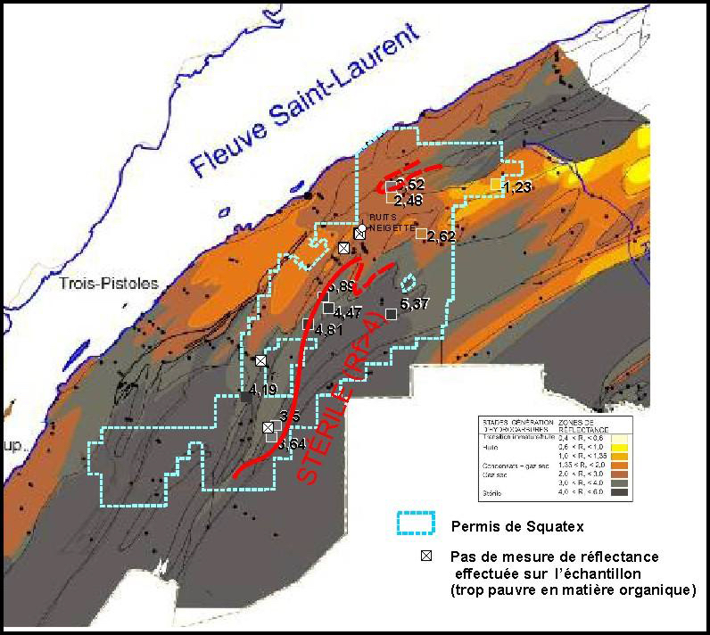
A more exhaustive sampling was done in June 2010 (close to 200 samples were gathered) in order to better cover the region. Fifty-four (54) samples were selected and sent to INRS for a supplementary analysis of the reflectance to complete the spatial coverage over the whole territory of the organic maturity analysis. Furthermore, 12 samples taken from the Soquip Lac Noir #1 Neigette (F005) well and four supplementary samples from the Sun Exploration and Al Mitis #1 (C088) well were sent for analysis to better understand the rate of growth of the maturity process with depth, which is a key factor in deciding the maximal prospective depth.
On the same occasion, a team of four geologists used the opportunity to verify the outcrops to help improving the geological knowledge and to revise government outcrops maps and thereby to better understand the tectonic structures.

1.4 Stratigraphic core holes program in the Lower St. Lawrence area
A stratigraphic drilling campaign (2 inches cores) was carried out in September 2010 over the Lower St. Lawrence permits, in order to validate the current geological interpretation. Nine (9) coreholes were drilled at depths of less than 300 m (Table 3).

Generally speaking, the main objectives of these stratigraphic coring were to:
- Validate certain photo-geological interpretations ,
- Identify the nature of certain magnetic anomalies that could constitute a marker horizon for the permits located in the northern part of the permits,
- Determine the nature and the behaviour of the Sayabec within anticlinal axes
- Verify the presence of hydrothermal dolomite (HTD) near major faults in the Rédemption complex region
- Take samples of the Trinité and Cabano Groups at a depth of at least 10 m in order to analyse their unaltered TOC content.
Figure 13 shows the location of the coreholes done during the 2010 drilling campaign in relation with the corrected geological map.
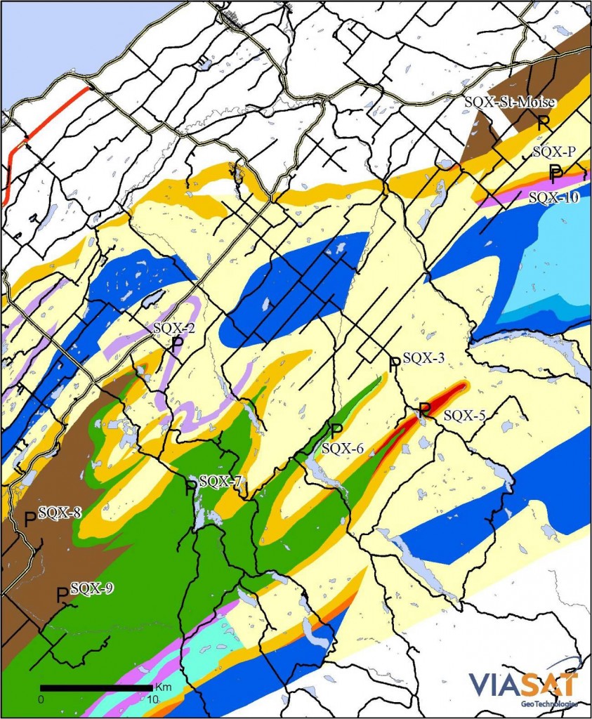
The coring campaign as a whole was a success to the extent that nearly all of the initial objectives were attained. Furthermore, the drilling information collected allowed the updating and validation of the existing geological map. Notably, there was a great improvement in understanding the source of the magnetic anomalies that were tested.
The first Squatex hole, the St-Moise well was drilled close to a previous hole drilled in 1954 by private interests, to an alleged depth of 800 feet (243 m). At the time, drillers reported the presence of oil, which was noted but not confirmed later by the Department geologist (Belland). The Squatex hole which reached 249 m went through a monotonous sequence of shale, silky when broken, even greasy and blackish in color and which could possibly be confused with showings of oil. Between 162 and 168 m, an odour of hydrocarbon was noticed, but nothing was found in the rocks (contamination?). The TOC analysis only gave 0.1%.
The St-Cléophas well (SQX-P) was drilled to a depth of 285 m (at an angle of 65o from the vertical). The drill ran into a nodular limestone with reefs facies of the Sayabec Formation up to a depth of 216 m. This limestone, which was sometimes fractured, brecciaed and dolomitized, proved to be very interesting with a high content of fossils and of reef fragments, bitumen and frequent odours of hydrocarbon (subsequently confirmed through analysis), as well as secondary porosity that was sometimes high. The section between 235 and 285 m is interpreted as the Val-Brillant Formation. Fracture porosity was sometimes observed. TOC analyses results were between 0.4% and 0.8%. The SQX-10 hole was drilled to the north of the SQX-P to reach and sample the Awantjish Formation. This 144 m hole attained its objective in reaching at its base 14 m of green shale below the Val-Brillant Formation.
Coreholes SQX-#2, #3, #5 and #6 were not as deep and were drilled in order to better understand the geological contacts (#2) or to identify (more or less successfully) the sources of magnetic anomalies (#3, #5, and #6). Drill holes #7, #8 and #9 were completed successfully and samples of the targeted groups (Trinité and Cabano) were collected for subsequent TOC analysis.
1.5 Reprocessing of seismic line MRN-2001-04
At the east end of the Lower St. Lawrence permits, the geology is highly complex. In order to better define it, Squatex chose to reprocess profile MRN-2001-04 that had been recorded and processed by the government, but was of insufficient quality to define what was really occurring at depth. Consequently, the original field data was sent to EarthSignal of Calgary to refine the processing parameters and to produce more information from the data. The results were very satisfying and were integrated to the regional interpretation.
2 WORK DONE IN THE ST. LAWRENCE LOWLANDS
2.1 Geochemistry
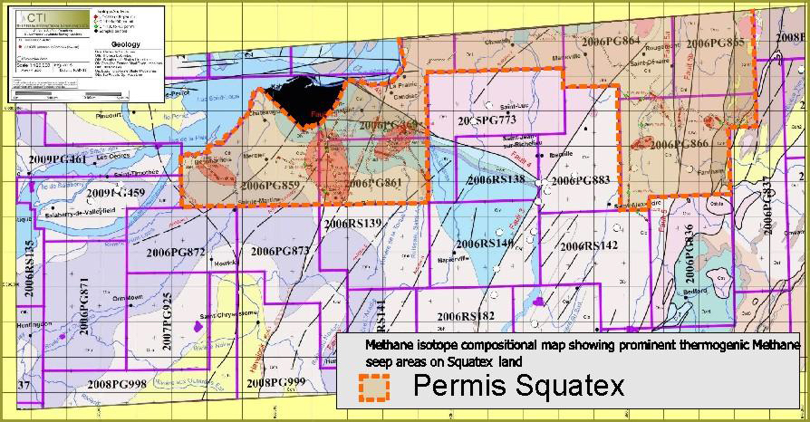
A geochemical sampling campaign was carried out in the overburden by CHEMTERRA INTERNATIONAL CONSULTANTS Ltd (CIT) in December 2009 and January 2010 over the SQUATEX's permits located south of Montreal, namely 2009RS291 to 298. A total of 1290 samples were gathered at an average depth of 1.5 metres and were analyzed.
Several thermogenic gas anomalies were identified including the main one covering an area of more than 10 square kilometres to the south-west of Montreal (Figure 14). This anomaly corresponds to an anticline axis locally going through the carbonated platform and to the major Havelock Fault in the underlying basement. In this region, the St. Lawrence Lowlands shale section (Utica and Lorraine) has been eroded and only conventional reservoirs such as the hydrothermal dolomitization of carbonates or reservoirs in structures within sandstones or carbonates layers at a depth of less than a few hundred metres are of interest. The fact that the targeted locations in this region are not very deep makes exploration (drilling) inexpensive and attractive.
2.2 Seismic
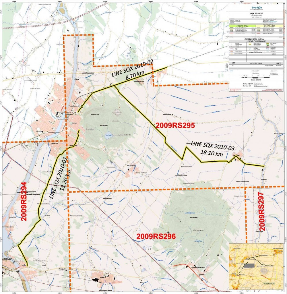
Following the analysis and a preliminary interpretation of all the public seismic profiles available in the St. Lawrence Lowlands, it was decided in the spring of 2010 to complete the seismic coverage of the Chambly-St-Hyacinthe area close to the Monteregian Hills. A permit to do a geophysical survey was obtained from the MRNF to record 40 km of seismic data over permits 2009RS294 and 2009RS295. The survey was programmed entirely along roads and consisted of three profiles located to the north-east of Chambly in order to complete the coverage of the initial seismic program done in 2008.
The survey was recorded in the field by Tesla Exploration Partnership in August 2010 and the lines were processed by Earth Signal of Calgary. The profiles were interpreted and integrated to the database (Figure 15).
2.3 Forage
Following a major agreement with Calgary-based Canbriam Energy in November 2008 that included several drilling options in the St. Lawrence Lowlands, Canbriam agreed to drill a first well before the end of 2009 in order to earn a 60% share over 8000 hectares located within two of Squatex's permits (2009RS296 and 2009RS298).
The well was located close to Farnham south-east of Montreal (see Figure 16). Drilling began on July 9 and the rig was released on August 12 after having reached a total depth of 2507 m. It had gone through a thick Lorraine sequence before reaching the Utica at 1987 m. The Trenton was reached at 2332 m. Indications of gas were observed and the well was cased and suspended for further evaluation.
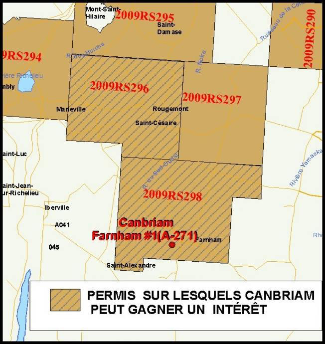
Just before beginning the initial drilling program in Farnham, Canbriam accepted in June 2009 to speed up its decision regarding the first option under the agreement, by committing an additional sum of $3.5 M ($2.45 M to Squatex and $1.05 M to Petrolympic) before November 30, 2009 and subsequently either to drill, case or abandon two more vertical wells in the Utica formation and/or 30 metres into the Trenton Formation before December 31, 2010 and thereby earn a 60% share over a second 8000 Ha block. The later date was extended a first time to December 31, 2011.
Consequently, according to the agreement, Canbriam maintains its other options of earning a 60% share over an additional 24000 Ha within permits 2009RS296 and 298 if it drills up to six additional vertical/horizontal wells and pays a sum of up to $13.5 M ($9.45 M to Squatex and $4.05 M to Petrolympic) before December 31, 2011.