April 2008-April 2009
The first major event that occurred in 2008 was the signing of a partnership agreement with Petrolympic Ltd. On June 30, 2008, an agreement was reached with Ressources & Énergie Squatex Inc. whereby Petrolympic Ltd bought a 30% interest in 36 exploration permits totalizing 672,438 hectares located in the St. Lawrence Lowlands and in the Lower St. Lawrence/Gaspé areas. In consideration for the purchase of this interest, Petrolympic paid an amount of $2.5 M pursuant to the final terms of the agreement. Of this amount, $1.8 M was used to do exploration work over the permits to satisfy work obligations.
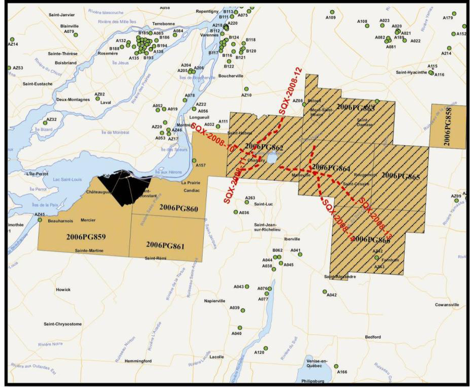
During the summer of 2008, a vast exploration program was set up by SQUATEX, including the acquisition of seismic profiles, pedogeochemical data, radiometric data and geological samplings. Reflection seismic data totalling 200 linear kilometres was recorded over properties in the Lower St. Lawrence and in the St. Lawrence Lowlands (Figure 1). The acquisition was made by Géophysique GPR/Kinetex and the processing of data was done by Calgary-based CGG-Veritas using parameters similar to those used in 2002 and 2005.

1 WORK DONE IN THE LOWER ST. LAURENCE/GASPÉ
1.1 Seismic survey
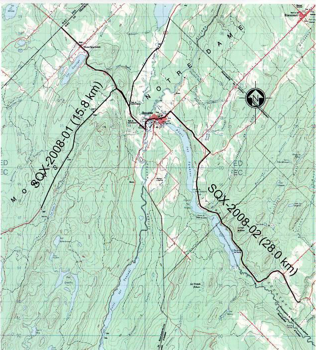
Four profiles were acquired in the Lower St. Lawrence totalling 74.5 km including two in the Squatec region (Figure 2), one south of Saint-Marcellin and the other in the Sainte-Jeanne-D'Arc area (Figure 3). Lines SQX-2008-01 and SQX-2008-02 attempt to detail the structure of the Squatec syncline and its genesis. Line 2008-03 is a regional transept west of lines MRN-02 and SQX-2002-01 that was recorded close to the SOQUIP Lac Noir Neigette No. 1 well. Line SQX-2008-04 was acquired between lines SQX-2005-01 and SQX-2005-02 in order to better define the anomaly targeted in the previous studies.

1.2 Radiometric survey
A radiometric survey was done by INRS-ETE on the Lower St. Lawrence property between October 2008 and November 2008. Based on the premise that areas having significantly high uranium values and low in thorium and potassium values were observed above or close to several hydrocarbon producing reservoirs.
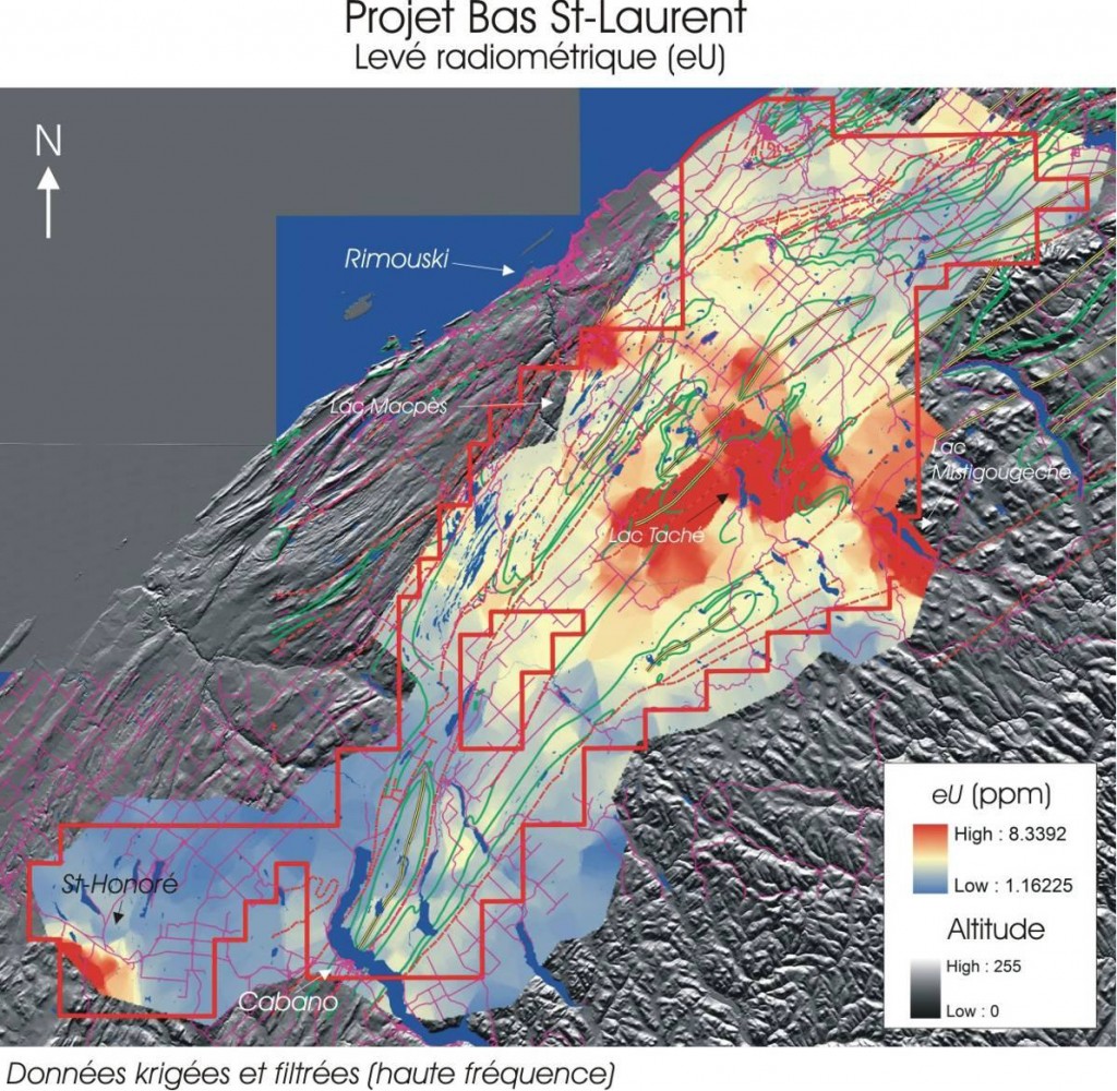
The objective of the study was then to measure radioactivity along roads, more specifically the emissions of uranium (U), thorium (Th) and potassium (K) in order to identify the areas having low values of Th and K (eluviated zones) and high values of U (enriched zones).
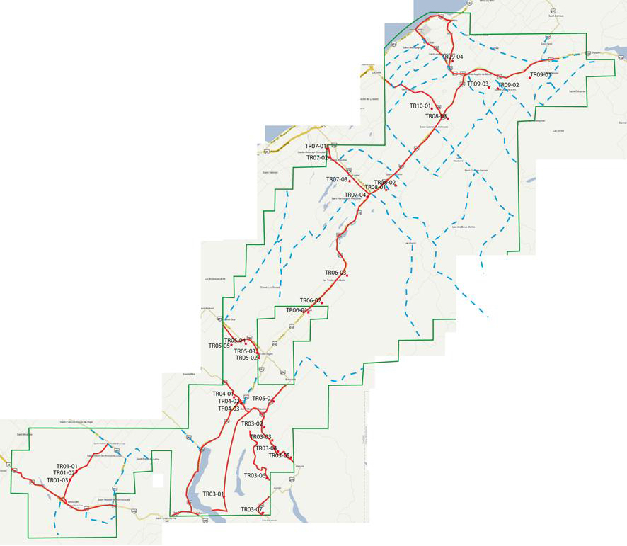
Figure 4 shows the trajectories of the survey done using a mobile radiometer. The various colors represent the different dates on which the survey took place. A total of 260,584 radiometric measurements were recorded.
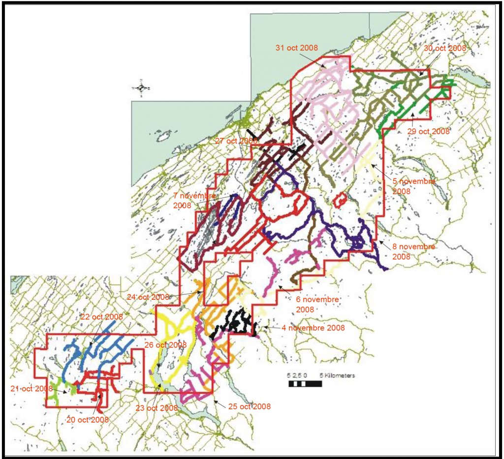
Figure 5 shows a color map of high frequency concentrations of U. Anomalous Uranium areas can be identified. The northern part of the Rimouski wildlife reserve (areas of Lake Taché and Lake Mistigougèche) as well as the Mt-Lebel area (north of Lake Macpès) south of the municipality of Rimouski should be pointed out. A third area was observed at the south-west extremity of the property, more specifically south of the village of St-Honoré-de-Témiscouata.
Certain zones with anomalies similar to those of uranium were pointed out. According to INRS, certain large zones with anomalies in U and Th could be the result of primary lithological characteristics.
Certain areas of the Lower St. Lawrence permits did have radiometric values that are characteristic of oil and gas migration. However, additional processing of the data is required to cross-check these anomalies before doing any further field investigation.
Furthermore, according to INRS, a loss or a reduction of the signal may be recorded when water saturation is high or when there is a superficial layer of organic matter that has low radioactive nuclides.
The method also has other limitations. The type of substrate, the presence of outcrops, variations in soil humidity, vegetation, elevation, entropic structures are all parameters that could influence the intensity of the gamma rays recorded by the detector. The uranium/potassium ratio may thereby be highly biased if the uranium concentrations are too weak and close to the limits of detection.
1.3 Pedogeochemical survey
A pedogeochemical survey was done by INRS on Squatex's Lower St. Lawrence property between October and November 2008. Soil samples were taken along five transects at an average sampling interval of 150 m, for a total of 368 sampling sites (see Figure 6). Physical and chemical analyses and geophysical measures were performed on the samples, together with measures of gas for methane, ethane, propane and butane (n-butane and i-butane) as well as for acetylene and propylene.
The objective of the study was to measure the content in C1-C4 hydrocarbons (methane, ethane, propane, butane) in the ground, as their presence could indicate the migration of hydrocarbons from underlying reservoirs.

Methane is generally abundant in nature and is often of biogenic origin and related to recent degradation of organic matter. As regards ethane, scientific literature considers it as an essentially thermo-genetic gas, which explains its systematic utilisation to identify targets for oil and gas exploration.
The results of the analysis of these samples obtained from the INRS survey, more specifically the concentration ratios between ethane and propane and between ethane and ethylene, show that the majority of the hydrocarbons detected in the soil would appear to be of thermo-genetic origin. Occasionally, some anomalies are of biogenetic origin. They are characterized by high concentrations of ethylene and by very high ratios of ethane/propane.
Again, according to INRS, the ratios of methane/ethane and of methane/propane strongly suggest that the C1-C4 hydrocarbons sampled along the five sections come mainly from condensates or dry gases seepages. In other words, the more the ethane/propane ratio is high, the more the origin is likely to be biogenetic, and the more the ethane/ethylene ratio is high, the more it is likely be of thermo-genetic origin.
According to INRS, three areas located along the Squatec Section (Figure 7) have significant C1-C4 hydrocarbon anomalies with ethane and propane values eight times higher than the background values. The southern part of Lake Pain de Sucre should also be noted with concentrations of ethane locally above 1800 ppb and those of propane above 400 ppb.
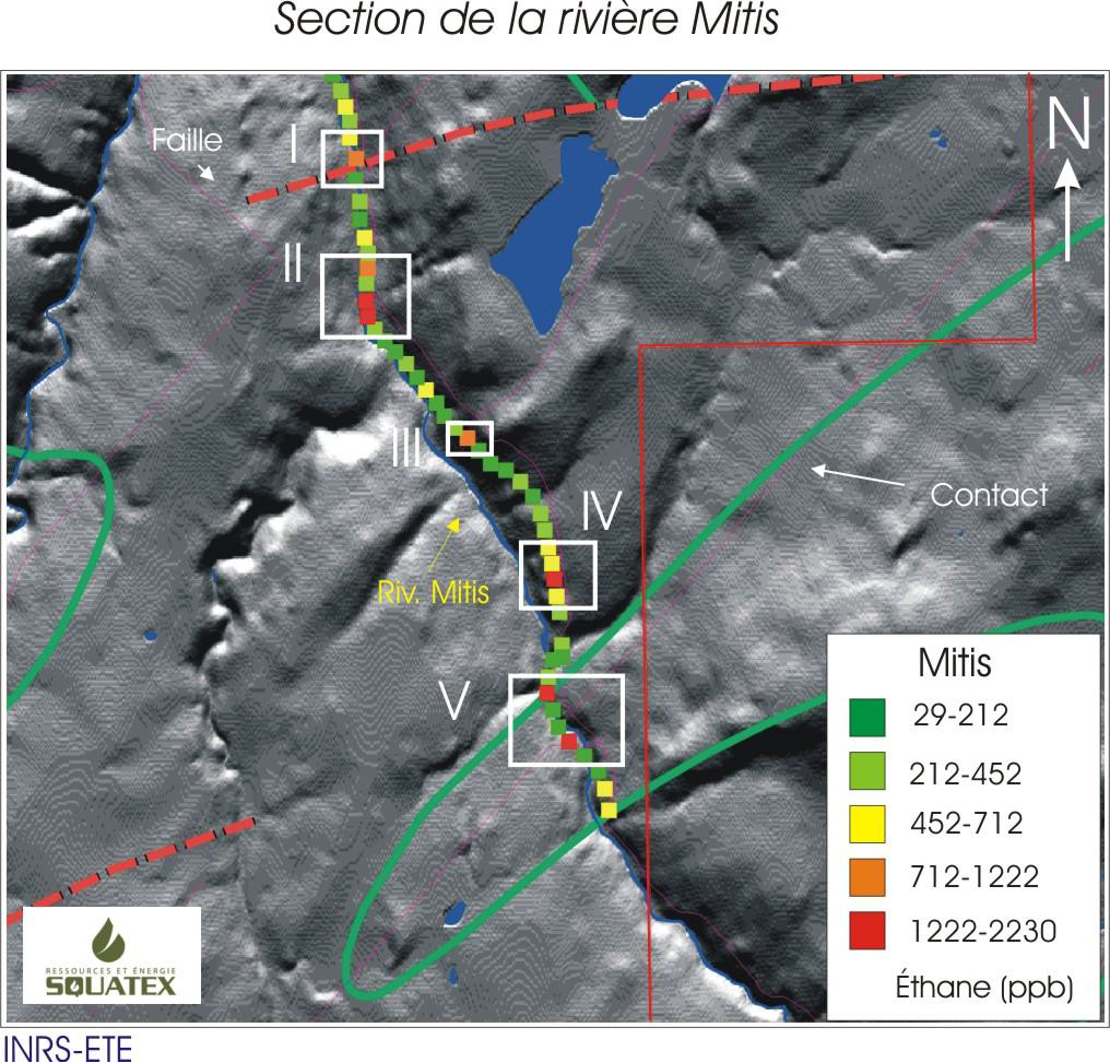
The spatial distribution and the high concentrations of ethane in the soil samples taken along the Mitis River Section (Figure 8) show strong anomalies in five sampled sites, observed in the center-north and center-south parts of the Section. The ethane concentrations exceed 1000 ppb and the propane and butane concentrations are also high.
Field investigation is therefore needed for these areas to validate the existing measurements and to check regional faults or fold zones that may have favoured these high concentrations. These areas are characterized by several ethane and propane anomalies.

1.4 Sampling and geological reconnaissance campaign
From October to November 2008, a geological sampling campaign was carried out in the field over the Lower St. Lawrence property. The purpose of the fieldwork was to collect samples in order to analyse their total organic carbon or TOC content. This field campaign led to a better understanding of the geological complexity of the Lower St. Lawrence area.
In all, 34 samples were taken mainly in the regions of St-Honoré, St-Michel-de-Squatec, Auclair, Trinité des Monts and Ste-Blandine. The areas covered were for the most part composed of rocks from the Cambro-Ordovician to the Devonian (Figure 9). The south-west part of the Squatex property is made up of shale from the Trinité and Cabano Groups, respectively of Canbriam and Ordovician age, and of the Chaleur Group made up of Silurian rocks that may be good source and/or reservoirs rocks. The samples that were taken were kept for subsequent analysis of their total organic carbon (TOC) content.
2. WORK DONE IN THE ST. LAWRENCE LOWLANDS
2.1 Seismic Survey
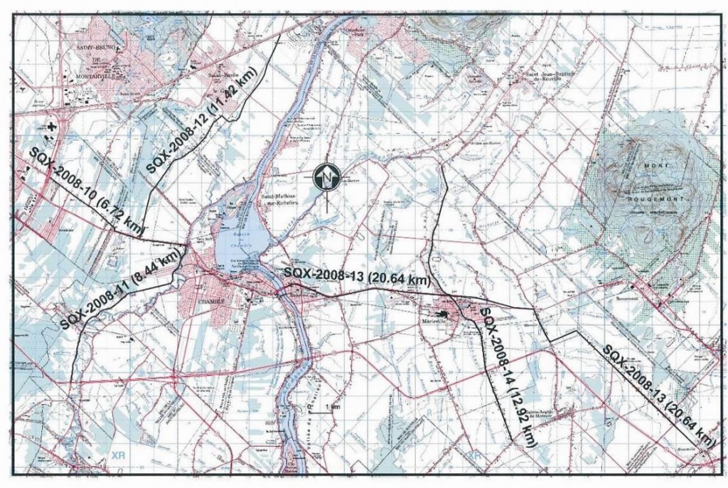
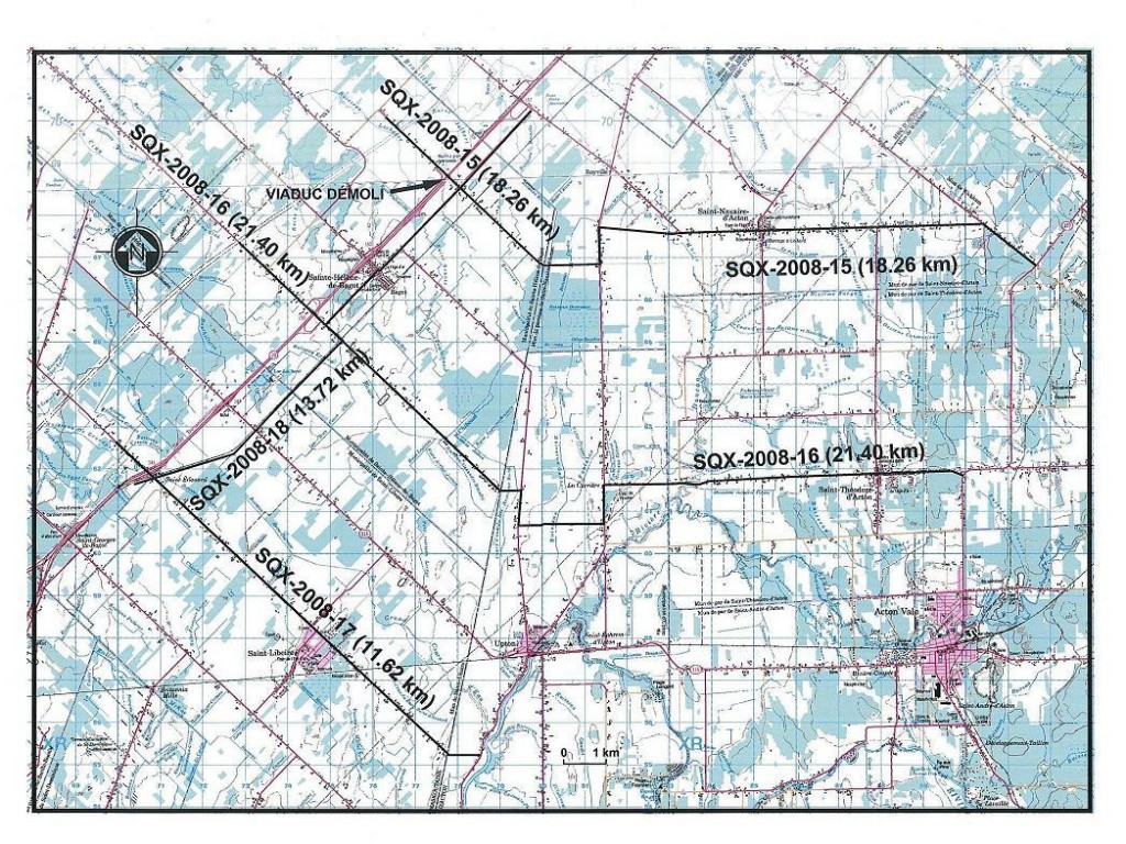
A seismic survey was also recorded in the St. Lawrence Lowlands subsequently to the one in the Lower St. Lawrence in September 2008. It had a total length of 123.4 linear km and consisted of nine profiles over two zones, Chambly and Sainte-Hélène. Lines SQX-2008-10 to 14 detail the Chambly area (Figure 10) in high resolution and lines SQX-2008-15 to 18 shed more light on the overlapping zone of Ste-Hélène-St-Simon (Figure 11).
2.2. Autres activités de SQUATEX dans les Basses-Terres
On November 25, 2008 Squatex and its partner Petrolympic Ltd concluded a joint operation agreement with Calgary-based Canbriam Energy Inc. (Canbriam). Canbriam was thereby given the possibility of acquiring a 60 % interest over an area that could total up to 32,000 Ha within two Squatex permits in the shale gas zone (Utica and Lorraine). The agreement dealt solely with the geological formations above the Trenton, namely the Queenston, the Lorraine and the Utica.
At the signing of the agreement, Canbriam paid $3.5 M ($2.45 M to Squatex (70%) and $1.05 M to Petrolympic (30%)) and agreed to choose within three months the two permits on which the agreement rests. On that date, Canbriam selected current permits 2009RS296 and 298. Canbriam also agreed to drill a vertical well up to the base of the Utica Formation and/or 30 meters through the Trenton before October 31, 2009 (the initial exploration program).
As provided for in the agreement, after having completed the initial phase, Canbriam will select a first block of adjacent land (done in April 2010) covering 8,000 Ha over which it now has a 60% interest in the strata above the Trenton. Squatex and Petrolympic respectively hold 28% and 12% of this territory.
DaCanbriam has the option after the initial phase of earning a 60% interest in an additional 24,000 Ha within the two farmed permits by drilling up to six additional wells (vertical and horizontal) and by paying amounts totalising $13.5 M ($9.45 M to Squatex and $4.05 M to Petrolympic). Canbriam is responsible for all costs relating to the drilling of the wells, to their completion and their abandonment As part of the agreement, Canbriam also bought from Squatex 40 km of seismic lines and acquired an aeromagnetic survey in December 2008 above permits 2009RS294 to 298 (formally 2006PG862 to 866) (see Figure 12). This data as well as the public data that is available allowed Canbriam to select the drilling sites suggested for February 2009.