2003-2005
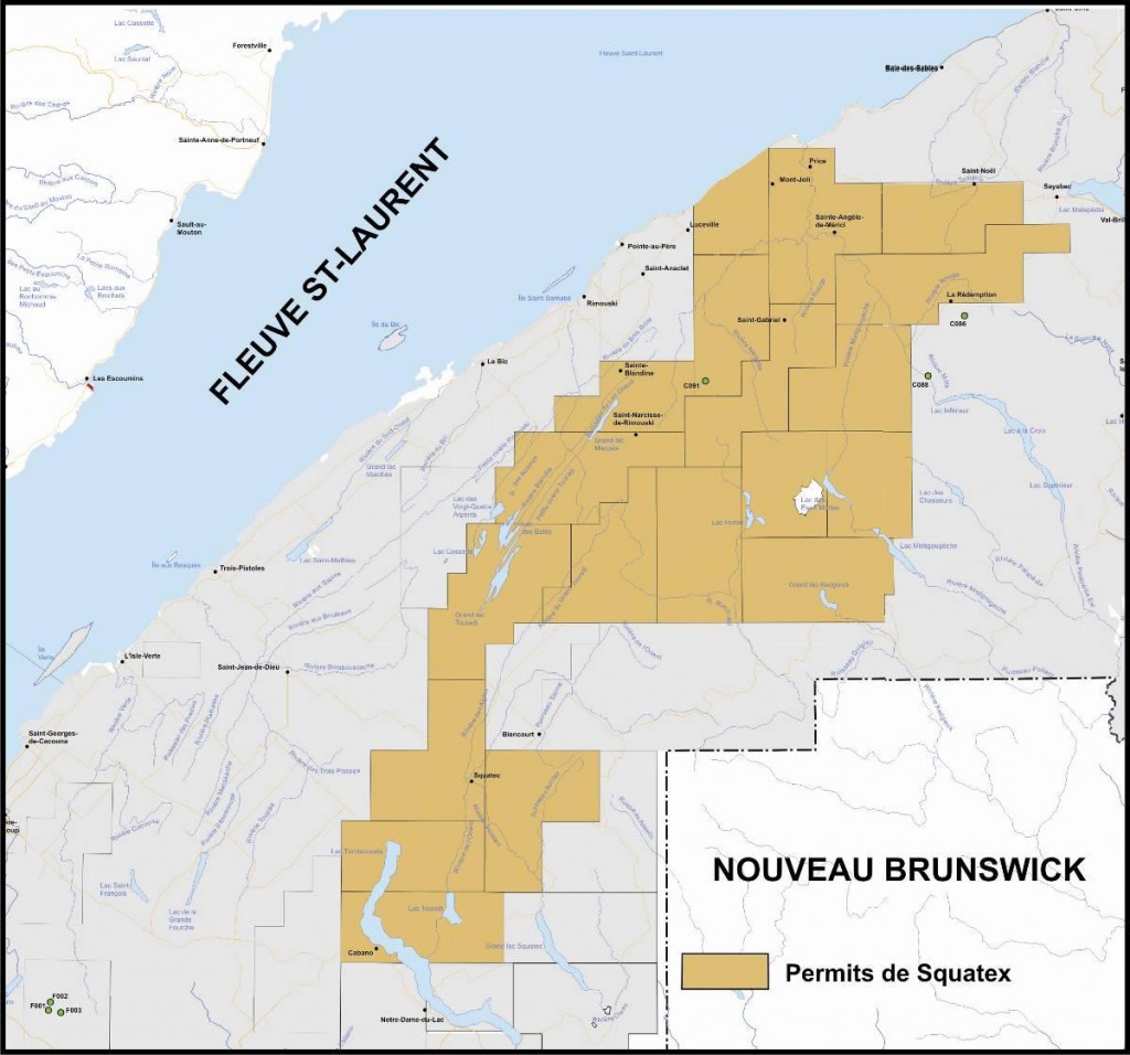
In 2003, nine new permits consolidated the company's mining rights towards the south-west up to the Témiscouata region. At the end of June 2003, Squatex had 18 permits representing oil and gas rights over a total area of 362,648 Ha (see Figure 1).
Squatex's next initiative was to retain the services in the fall of 2003 of Mr. Paul Laroche, P. E., P. G. of Roche Ltée Groupe Conseil to develop, coordinate or perform and supervise all of the oil and gas exploration work over its permits.
The first part of the work consisted in obtaining the geoscientific data available for the region. Public records dealing with oil and gas geology and structural geology were consulted. Most of the available data was found in documents published by INRS and the Geological Survey of Canada. Basic data and results from eight wells drilled in the region between 1957 and 2002 were consulted and allowed a better understanding of the geological and structural complexity of the land covered by the permits.
The studied region has the basic elements looked for when seeking petroleum reservoirs. The work done by INRS/Géoressources showed the presence of necessary source rocks, reservoir rocks and sealing rocks that are fundamental for the discovery of oil and gas.
All available seismic lines were obtained and interpreted. The processing by CGG-Veritas of line SQX-2002-01 gave better quality results than for line MRN-2002-02 located 10 km to the east (Figure 2). Because of these encouraging results, there was a reprocessing by (CGG-Veritas) of the southern half of profile MRN-2001-02 that had previously been processed by GAPS (Geophysical Processing Services Ltd). The resulting data was considerably of better quality and allowed a better assessment of the prospects identified on Squatex's line.
In 2003, seismic interpretation was performed on lines SQX- 2002-01 and on the government lines acquired in the region, namely MRN-2001-02, MRN-000-08, MRN-2000-03, 04, 06 and MRN-2001-04 totalling 136 km of profiles.
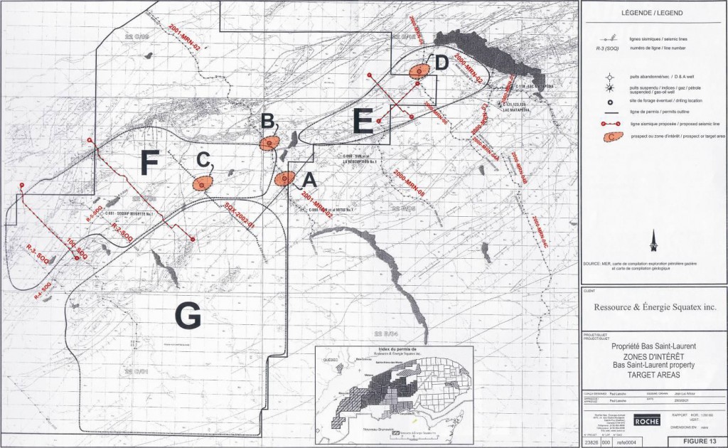
The author pointed out that “the review of the seismic lines greatly contributed to a better understanding of the region's structural context and to identifying areas that could be investigated in the future”. Because of the limited amount of seismic data, a full assessment of the property's potential could not be done. However, it did show that there could be interesting possibilities in the Eastern part of the property (see Figure 2).
The author identified four zones with anomalies (A, B, C and D) and three zones of interest (E, F, and G). He recommended acquiring an additional 68 km of seismic profiles to attempt to demonstrate possible prospects in the Eastern part and continuing the reconnaissance of the land towards the west (zone F). He recommended doing two stratigraphic coreholes over anomalies A and D. The estimated cost of this work was $600,000 (purchase of 55 km of old seismic profiles and two coreholes).
In 2004, Squatex joined forces with Junex, Gastem, the MRNF and the Geological Survey of Canada to acquire a large high resolution aeromagnetic survey above the northern part of the Gaspé Peninsula. The data obtained from this survey was very helpful in understanding the surface structural geology over the eastern limit of the permits. In fact, this type of survey is very useful for regions where the level of oil and gas exploration is low.
Furthermore in 2004, CGG-Veritas was retained to run a special processing in the southern part of line MRN-2001-02. This AVO processing in taking separately the results obtained from the near traces and from the far traces to compare them has permitted the identification of apparently porous zones containing fluids in the central part of the profile.
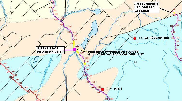
In February 2005, Paul Laroche, P. E., P. G., Independant Consultant, presented a preliminary report proposing to drill a stratigraphic well on the main apparent porous zone (Squatex Mitis No. 1). This document provided the basic data required to set up a stratigraphic well to assess the potential presence and accumulation of hydrocarbons at the base of the Silurian sequences near the Mitis River, in line with the possible extension of the Shickshocks-South Fault in the Lower St. Lawrence region.
The selected drilling site was deemed to be the most promising following an in-depth review of the surface geology compiled from various data sources, coupled with satellite images, and following an AVO analysis of the MRN-2001-02 seismic profile (see Figure 3). The proposed well location was at VP 1205 of line MRN-2001-02 approximately halfway between anomalies A and B on Figure 2.
In March 2005, a joint oil and gas evaluation report over the region south of Rimouski was submitted by MIR Télédétection Inc and Paul Laroche, consultant (see the blue box identifying the specific area in Figure 4). The purpose was to assess the hydrocarbon potential of the area covered by Squatex's permits and revise the published geology maps that were deficient in many regions.
Consequently, teledetection data (LANDAT and SPOT images), as well as aeromagnetic, gravimetric, seismic and geochemical data were integrated and analysed in order to identify the principal tectonic mechanisms that created the geological structures and to identify the areas that could have potential for the presence of oil and gas.
This study allowed a better definition of the geological axes and of the effect of tectonic forces in the region and, consequently, a better targeting of the zones with oil and gas potential. The surface geological map that was generated suggests a new perspective on the mechanics of the deformation forces that shaped the particular tectonic style of this territory. The center of the region under review is characterized by an important fragmentation of the geological units and the knowledge that was gained provided direction for the geophysical interpretation.

Interpretation of the government's and Squatex's seismic profiles helped to identify the major syncline and anticline axes as well as the major fault zones, particularly in the eastern part of Squatex's property. From an oil and gas perspective, the results led to the division of the eastern half of the property into different zones of interest (A to G in Figure 2) according to the type of anomaly encountered or according to the particular environment for sediment deposits, thereby permitting a better targeting during subsequent exploration work in the region.
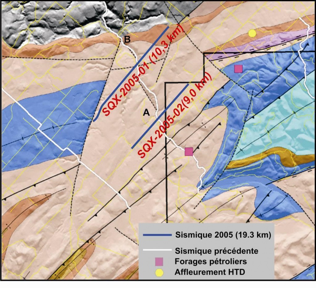
The new AVO processing of the MRN-2001-02 line demonstrated that the porous areas observed on the seismic survey could be compared to the outcrop of hydrothermal dolomite containing showings of hydrocarbons (the Sayabec Formation) found close to the town of St-Cleophas. The approach used was a wise one, because this type of reservoir is the most promising in this region. Following the interpretation of the seismic data, exploration targets were identified within a triangle delineated by zones having probable faults in the north-eastern part of the permits. The reprocessing of the seismic data to analyze fluids confirmed the potential of the two targets identified during the initial analysis of seismic data. It was recommended that an acquisition program be undertaken for 45 km of new seismic lines west of La Rédemption in order to check the interpretation of potentially normal faults in a north-west direction which could also act as a closure for the two targets identified as A and B in the previous study done in 2003 (see Figure 5 as well as previous Figure 2).

Following this recommendation, it was decided in the summer of 2005 to acquire two seismic lines of lesser length than the one initially suggested (19.3 km instead of 45 km) because of budgetary constraints. They were 10.3 and 9.0 km in length respectively (see Figure 6). The acquisition was made by Conquest Geophysical of Calgary and the processing by CGG-Veritas of Calgary (Final Stack, Pre-Stack Migration and Post-Stack Migration). The preliminary interpretation of these new seismic lines in the fall of 2005 confirmed the location of the proposed drilling site.